Sidestruktur
-
Spitsbergen-nyheter
- Velg måned
- juni 2025
- mai 2025
- april 2025
- mars 2025
- februar 2025
- januar 2025
- desember 2024
- november 2024
- oktober 2024
- september 2024
- august 2024
- juli 2024
- juni 2024
- mai 2024
- april 2024
- mars 2024
- februar 2024
- januar 2024
- desember 2023
- november 2023
- oktober 2023
- september 2023
- august 2023
- juli 2023
- juni 2023
- mai 2023
- april 2023
- mars 2023
- februar 2023
- januar 2023
- desember 2022
- november 2022
- oktober 2022
- september 2022
- august 2022
- juli 2022
- juni 2022
- mai 2022
- april 2022
- mars 2022
- februar 2022
- januar 2022
- desember 2021
- november 2021
- oktober 2021
- september 2021
- august 2021
- juli 2021
- mai 2021
- april 2021
- mars 2021
- februar 2021
- januar 2021
- desember 2020
- november 2020
- oktober 2020
- september 2020
- august 2020
- juli 2020
- juni 2020
- mai 2020
- april 2020
- mars 2020
- februar 2020
- januar 2020
- desember 2019
- november 2019
- oktober 2019
- september 2019
- august 2019
- juli 2019
- juni 2019
- mai 2019
- april 2019
- mars 2019
- februar 2019
- januar 2019
- desember 2018
- november 2018
- april 2000
- Velg måned
-
Værinformasjon
-
Newsletter

| Svalbard-guidebok som ebok |
Home
→ desember, 2018
Måneds-Arkiv: desember 2018 − Nyheter og Reiseblogg
Fiskebåt i seilulykke i Hinlopenstredet
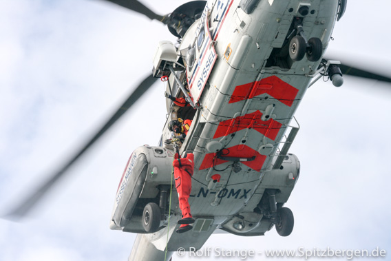
En fiskebåt havnet i alvorlig trøbbel i Hinlopenstredet nord på Svalbard, opplyser Søk- og Redningssentralen i Nord-Norge. Det norske skipet «Northguider» sendte inn et nødsignal klokken 13:22 lokal tid fredag, og redningstjenesten i Longyearbyen og Nord-Norge ble satt i aksjon. Snart hadde begge redningshelikopterne fra Longyearbyen lettet, og den første ankom åstedet klokken 15:15, mindre enn 2 timer etter nødanropet hadde nådd redningssentralen i Nord-Norge. Samtidig ble luftfartøyet Orion sendt fra Andøya. Avhengig av type kan disse luftfartøyene brukes til redningsoppdrag til for eksempel å søke etter savnede fartøy eller personer, eller til å overvåke mulige oljelekkasjer.

Sysselmannens redningshelikoptere, her vist under en øvelse.
Den gode nyheten er at alle ser ut til å være i god behold. Mannskapet på 14 var utstyrt i overlevelsesdrakter og hadde gått til baugen for å bli hentet av redningshelikopterne. Ifølge skipseieren er alle ved godt mot og i god fatning, omstendighetene tatt i betraktning. Ingen ble skadet eller tilbragte tid i det kalde vannet.
Skipet «Northguider» later til å ha truffet grunnen på kysten langs Nordaustlandet sør for Murchinsonfjord. Skipet ligger nå på grunnen med en ca. 20 graders helning, men stillingen ser ut til å være stabil enn så lenge. Været, som med 18 minusgrader og sterke vinder (Beaufort 6) sammen med mørket, gjør redningsoppdraget svært utfordrende, men det er ingen grunn til å tro at den norske redningstjenestens profesjonelle ikke skal få alt mannskap av skipet snart.

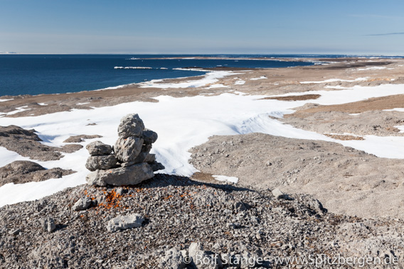
Kalkstrandern i Hinlopenstredet, sør for Murchisonfjord: her skal skipet «Northguider» ha grunnet et sted. Forholdene her er svært forskjellig fra slik det er vist på bildet, med mørke, kulde og sterk vind.
Kystvaktens skip KV Barentshav har satt kursen for Hinlopenstredet, men er ikke forventet å nå området før lørdag. Polarsyssel, Sysselmannens tjenesteskip, er ikke tilgjengelig til bruk på Svalbard om vinteren.
Oppdatering: Redningssentralen i Nord-Norge har informert om at alle 14 mannskaper har blitt fraktet i helikoptere til Longyearbyen, hvor de blir ivaretatt. Skipet «Northguider» ligger fortsatt grunnet, og tar inn vann.
Med nye panoramaer i det nye året
In 2018, again I had plenty of opportunities to shoot arctic panoramas, making these interesting and beautiful (well in some cases, it is interesting or beautiful) easily accessible for everybody. Physically, most of them are pretty much inaccessible for most people. A panorama photo does not physically take you to, say, a mountain top on Prins Karls Forland, but it is the next best thing – it gives you the feeling to be in the middle of the landscape, you can just turn around and enjoy the full view of the arctic landscape.
Over 5 years now, the by far largest digital museum of Spitsbergen (Svalbard) has thus come into existance. And it keeps growing. It takes quite some time and effort to turn the 18 RAW files (35, in some cases) into one panorama and to make that part of a dedicated little website or even to turn many panoramas into one virtual tour, such as the school / kindergarten in Pyramiden. In many cases it has taken years for material to progress on the list to the point where it actually appears on the website.

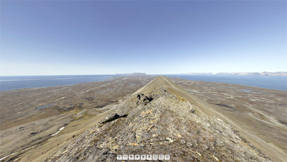
New Spitsbergen panoramas: the round view from Persiskammen, in the southern part of Prins Karls Forland, is just one out of many
(this here is just a screenshot without panorama function).
Here is a choice of new Spitsbergen panoramas that we have made during the last couple of months and weeks – a little Christmas-/New Years’s present for the Spitsbergen community:
- Pyramiden: School / Kindergarten. In October the whole collection of Pyramiden panoramas had moved to a dedicated little map so you can find your way around as you take a little walk through the old ghost town, possibly visiting a building here and there. And we added some new panoramas, including the school / kindergarten, which is our largest single virtual tour so far – the building has 3 floors! Other new ones include the old mines.
- Barentsburg: also here we did not just add new material, but we sorted the panos on a dedicated map, so you know where you are. New panoramas include the brewery, Lenin, the chapel, …
- And while we were at it, of course also Ny-Ålesund had to get its own map to make the whole thing proper. And also here we took the opportunity to add some new panoramas, including Amundsen, the Kongsfjordbutikken, the museum, the Green House, the airshipmast, …
- Let’s get out of the settlements and into the wilderness. Murraypynten is a point on Prins Karls Forland with some fine views.
- Another one on Prins Karls Forland. Nesungen is on the outer side of the island, which is exposed and rarely visited.
- Last but definitely not least from Prins Karls Forland. The view on Persiskammen, this lonesome mountain in the south of the island, is just stunning!
- Elfenbeinbreen in Agardhdalen, not far from the east coast.
- Buchholzbukta is not far from Heleysund, as far east on the main island of Spitsbergen as you will get.
- Polhem in Mosselbukta was Nordenskiöld’s base during his 1872-73 wintering.
- Foxfonna is a little ice cap close to mine 7. Amazing winter views in central Nordenskiöld Land.
- Rijpsburg on Bohemanflya is not just the site where the first commercial coal mining took place in Spitsbergen. It is also a beautiful place.
- Finally back again to civilisation. The taubanesentrale (coal cableway centre) is one of Longyearbyen’s eye catchers. Normally it is closed, but here and now … – welcome in!
- One of Spitsbergen’s most difficult-to-get-to places is the famous Global Seed Vault). Once again: welcome in!
Enjoy – and happy new year!
Nyhetene er i fra 15.06.2025 klokken 01:00:20 (GMT+1)


